

How NASA Builds Resilience with Climate Models
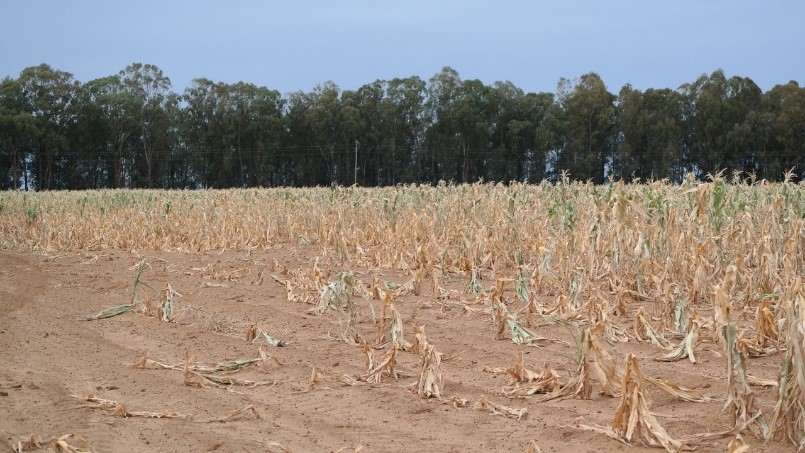
Climate change impacts all of us in various ways. Changes in soil moisture have a pronounced effect on agricultural production, which in turn impacts the food we grow to eat. Changes in precipitation patterns are leading to increases in drought in certain regions and causing flooding in others. All of these impacts are influenced by interactions among processes within the Earth system involving the atmosphere, ocean, land, ice, and life. These natural interactions, combined with human influences such as the release of greenhouse gases, serve to drive the climate system resulting in distinct regional variability of climates across the globe.
The interconnectedness of Earth’s systems is complicated, and a significant change in any one component of the system can exacerbate changes to the climate, effecting our communities and livelihoods in countless ways. In 2020, the U.S. alone sustained 22 separate billion-dollar weather and climate disasters - that included wildfires, drought, severe weather, and hurricanes that totaled over $95 billion in damage costs. But understanding and quantifying how the climate system will change, and predicting its impact on communities in different regions of the U.S. and around the world, remains a massive scientific undertaking.
NASA satellite data and model forecasts regularly help agricultural and aid agencies monitor the performance of crops worldwide and prepare for food shortages. Credit: USDA / FAS / Curt Reynold
One way to address this issue and predict the impacts of climate change is using climate models. “Climate modeling is one of the only ways to see the future,” explained Dr. Kate Marvel, an associate research scientist who studies climate forcing and feedbacks at the NASA Goddard Institute for Space Studies (GISS) and Columbia University. Scientists do not have observations of the future, but models can help provide that view by understanding complex systems and working through complicated problems. Models allow us to test how the climate responds to changes, such as the impact of CO2 emissions on Earth’s systems or changing precipitation patterns, and examine the potential impacts of different policies.
Climate models can then support decision-making across communities spanning the humanitarian, public heath, energy, water, and agricultural sectors, enabling better crop forecasting, water resource management, and disaster management activities. These models can also address pressing questions such as what environments are likely to produce severe weather, how to prepare infrastructure to ensure climate resilience, and how our decisions today can affect how Earth's climate may change in the future.
How do Climate Models Work?
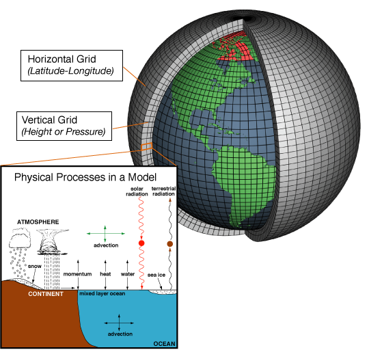
This image shows the concept used to build climate models. Each of the thousands of three-dimensional grid cells can be represented by mathematical equations which describe the materials in them, and the way energy moves through them. These advanced equations are based on fundamental laws of physics and chemistry. To "run" a model, scientists divide the planet into a 3D grid, apply these basic equations, and evaluate the results. Atmospheric models calculate winds, heat transfer, radiation, relative humidity, and surface hydrology within each grid box, and evaluate the interactions with neighboring boxes. Credits: NOAA.
Climate models provide a view into Earth’s future climate and come in different forms- from covering a particular region of the world or part of a climate system, to those that simulate the atmosphere, oceans, land and ice for the entire globe.
These models are based on well-documented and measured physical and chemical processes of Earth’s systems, which are represented by mathematical equations. Dr. Min-jeong Kim, a research scientist within NASA’s Global Modeling Assimilation Office (GMAO) and Morgan State University, expands on this, explaining that “these equations are composed of large number of variables at thousands to millions of data points and are impossible to solve using pen and paper. Therefore scientists translate these equations into computer code and make climate models. Scientists use these climate models to understand complex Earth system components and calculate their future states.”
Each model works by dividing the atmosphere into a three-dimensional grid and calculating what goes on within each box of that grid. Scientists input data from observations of temperature, humidity and pressure, and the model uses physics to compute how weather will develop within each box, what effects those developments will have on neighboring boxes, and what effects those neighboring boxes will have on their neighbors, thus allowing an understanding of the effects over a particular region or the entire globe.
The output from these models helps drive decision-making across timescales from seasons to decades, helping scientists understand how human activity is affecting Earth’s climate. They allow us to understand changes in the behavior of severe storms, improve predictions of fire seasons and droughts, which enables informed climate policy decisions on national and international scales.
Predicting the Future of Earth's Climate with NASA Data
To help develop these climate models, scientists around the world rely on a wealth of data provided by NASA. NASA has been providing scientists with global satellite observations and critical environmental datasets to help analyze and predict Earth's climate for decades. These data are being used to investigate global patterns of change in the Earth’s atmosphere, land, oceans and ice to support model development and operation for predicting future climate conditions.
Unlike ground-based monitoring tools that do not provide adequate coverage in many regions of the world, satellites provide a consistent, global view of environmental variables that influence Earth’s climate.
“NASA is a leader in making space-based measurements of climate variables, including precipitation, cloud coverage, water vapor, and temperature, over long periods of time,” said Dr. Greg Elsaesser, a research scientist at the NASA GISS and Columbia University who uses satellite observations to improve global climate models. Data from NASA feed into equations within climate models at NASA, the National Oceanic and Atmospheric Administration (NOAA), and a range of international agencies including the Japan Meteorological Agency, to improve their predictive capability. Climate models then are able to predict weather averages and other climatic properties from a few weeks to several years and decades in the future, giving stakeholders the best available science to guide their decisions that directly impact society.
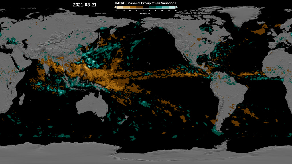
The 20-year record of the Integrated Multi-satellite Retrievals for GPM (IMERG) product can provide valuable information on seasonal and regional averages of precipitation, or climatologies. By comparing the progression of the observed precipitation with a climatology, we can generate maps showing how much current conditions depart from the average. This image shows variations from the average precipitation on August 21, 2021, where blues indicate higher observed rainfall and browns indicate lower observed rainfall compared to the average. Researchers sometimes refer to these deviations from the climatology as "precipitation anomalies". This information can be used to help improve and evaluate climate models. View the latest IMERG precipitation anomalies animation here. Credits: NASA Goddard Scientific Visualization Studio.
At NASA, several programs are committed to improving model development and working towards improved climate predictions. From NASA GISS’ E3 climate model to NASA GMAO’s Goddard Earth Observing System (GEOS) model, scientists use near real-time to long-term records of NASA observations as input to help initialize, develop model parameters, and validate these climate models. These approaches are critical processes to improve the predictive capability of a model.
As one example, the GEOS model leverages real-time precipitation data from NASA’s Global Precipitation Measurement (GPM) mission to generate the initial conditions of the environment using data assimilation techniques. This is necessary to develop model parameters and start a climate model “run”. This type of information has been essential to improve location and intensity estimates of storms, which can directly benefit disaster monitoring and response efforts. Additionally, the use of NASA data through these model activities can strongly impact the accuracy of seasonal and long-term forecasts, affecting our ability to plan and make informed decisions for water resource and crop management activities.
The use of NASA observations for climate modeling activities is essential for planning for a changing climate and tackling the societal challenges that lie ahead. Climate models stand to benefit everyone who plans to build climate resilience, from government officials developing climate policies, to businesses building stronger infrastructures, to individuals deciding where to live.
Click here to continue reading about climate modeling techniques and how precipitation data from the GPM mission is supports climate modeling activities.
Learn More About NASA Climate Modeling
Interactive Story Maps
One Pagers
Precipitation Education:
Credits:
Story by Andrea Portier (NASA GSFC / SSAI)