Tropical Cyclone Jasper Brings Heavy Rainfall To Queensland, Australia
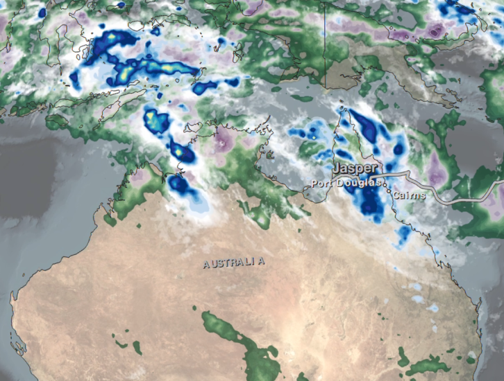
In mid-December 2023, the far north region of Australia’s Queensland state experienced heavy precipitation and flooding as a result of Tropical Cyclone Jasper, which made landfall on December 13 north of the town of Port Douglas. The Joint Typhoon Warning Center began issuing bulletins on Jasper on December 5 as it developed into a tropical depression over the Western South Pacific Ocean. By December 7, Jasper had strengthened to a Category 4-equivalent cyclone on the Saffir-Simpson scale as it tracked southwestward. By the time it made landfall on December 13, Jasper’s winds had weakened back to tropical depression strength. However, the storm then stalled over the Cape York Peninsula where its cyclonic circulation brought warm, moist northeasterly winds from the Coral Sea onshore, resulting in heavy precipitation along the coast for several days.
The above animation shows precipitation rates (in blue/yellow shading) and accumulations (in green/purple shading) from NASA’s IMERG multi-satellite product from Dec. 5-19, 2023. White contour lines highlight areas that exceeded 600 millimeters (~24 inches) of accumulated precipitation during the same time period. Cloudiness is shown in shades of white/gray using infrared geosynchronous satellite data. By the end of the animation, precipitation totals along parts of Far North Queensland’s east coast, including the areas around Port Douglas and Cairns, were estimated to have exceeded 600 millimeters (~24 inches). NOAA’s Climate Prediction Center, which collects data from an international network of rain gauges, reported monthly precipitation totals for the period ending on December 19 in excess of 600 millimeters in North Queensland as well, in a pattern broadly consistent with the IMERG totals. The Australian Bureau of Meteorology reported that some isolated locations near Port Douglas and Cairns saw even greater amounts, in excess of 2000 millimeters.
NASA’s IMERG algorithm combines data from multiple satellites to give meteorologists and water resource managers access to near-realtime views of storm systems like Jasper. The ability to estimate precipitation over large areas of ocean and land makes IMERG a valuable complement to more traditional precipitation observations from ground-based radars and rain gauges.
Credits:
Visualization and story by Jason West (NASA GSFC, PPS, KBR)

