Browse ESS2.D Resources
Browse ESS2.D Resources
Primary Topic:
Subtopics:
Type:
Standards:
Keywords:
Summary:
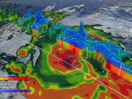
NASA researchers use a combination of satellite observations to re-create multi-dimensional pictures of hurricanes and other major storms in order to study complex atmospheric interactions. In this video, they applied those techniques to Hurricane Matthew
Primary Topic:
Subtopics:
Type:
Keywords:
Summary:
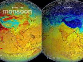
The monsoon is a seasonal rain and wind pattern that occurs over South Asia (among other places). Through NASA satellites and models we can see the monsoon patterns like never before.

Primary Topic:
Subtopics:
Type:
Keywords:
Summary:
This lesson uses cubes as a way to graph precipitation data to compare the precipitation averages and seasonal patterns for several different locations. There are several variations to accommodate various ages and ability levels.
Primary Topic:
Subtopics:
Type:
Keywords:
Summary:
You will learn how we measure rain and snow from the ground and from space using satellites, and why we need to check the data using ground validation. This particularly relates to the OLYMPEX Field Campaign.
Primary Topic:
Subtopics:
Type:
Keywords:
Summary:
You will learn how we measure precipitation from the ground and from space using satellites, and why we need to do ground validation of the satellite data. You will also learn about the OLYMPEX Field Campaign.

Primary Topic:
Subtopics:
Type:
Keywords:
Summary:
The second spinoff video for the Science on a Sphere film "Water Falls." This video looks at the uses and advantages of remote sensing.
Primary Topic:
Subtopics:
Type:
Summary:
GPM Application Science Lead, Dr. Dalia Kirschbaum, explains how GPM observes snow, and the importance of understanding snow characteristics and distribution in a changing climate.

Primary Topic:
Subtopics:
Type:
Keywords:
Summary:
GPM Project Scientist Dr. Gail Skofronick-Jackson and Deputy Project Scientist Dr. George Huffman narrate a look at the new GPM IMERG global dataset.

Primary Topic:
Subtopics:
Type:
Keywords:
Summary:
GPM Master Teachers and Pilot Teachers showed their students the data animation depicting six months of global precipitation, and asked their students to share their questions for NASA scientists about this new global portrait of rain and snow.

Primary Topic:
Subtopics:
Type:
Keywords:
Summary:
NASA and JAXA released the first images captured by their newest Earth-observing satellite, the Global Precipitation Measurement (GPM) Core Observatory, which launched into space Feb. 27, 2014.